
DEEP-OCEAN SENSING · TECH
An internet route can become an observation line
The striking part is not that glass responds to a disturbance. It is how much of the ocean one optical measurement can distinguish.
- The fibre is the sensing mediumA cable can reveal physical disturbances without thousands of separate instruments on the seabed.
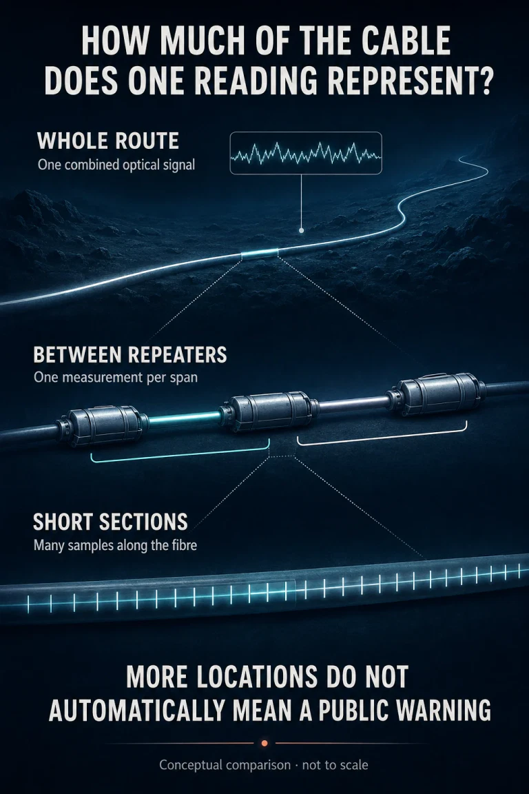
- Read the measurement scaleA whole-route signal and a short-section reading answer different questions about where a wave passes.
- Detection comes before interpretationA research observation is valuable evidence, but public warnings also require forecasts and operational decisions.
The ocean floor already carries an extraordinary network of glass. We normally judge it by the information it delivers intact. Scientists are learning to read something else: the tiny physical changes that the journey leaves on the light.
In a 2025 conference paper, Mikael Mazur and colleagues reported observing the magnitude-8.8 Kamchatka earthquake and its tsunami using a 4,400-kilometre California–Hawaii telecom cable. Their prototype resolved 100-metre sections, yielding roughly 44,000 sensing points. That is an impressive observation line, not a ship installing 44,000 instruments.
This is a closer look at an established experiment, with research checked through 5 September 2026, rather than a claim that the discovery happened today. Its importance becomes clearer when we ask a smaller question: how much cable contributes to a single reading?
The first trick was to listen to a route as a whole
The Caltech–Google Curie study published in 2021 monitored changes in the polarization of ordinary telecom light. Polarization describes the orientation of the light’s electric field. Changes to the fibre can alter it, allowing an optical receiver to register a disturbance without decoding the internet traffic as seismic information.
The researchers detected about 20 moderate-to-large earthquakes during nine months of observations. They also recorded effects associated with ocean swells, but did not detect a tsunami in that particular study. The whole link acted as a sensor: it could indicate that something had changed along the route without assigning a separate reading to every short stretch.
Think of the difference between knowing that a long corridor has become noisy and having a sequence of observations that shows sound moving through it. Both are useful. They are not interchangeable. The second lets the observer compare neighbouring locations, rather than infer everything from a combined result.
Repeaters make the return journey difficult
In distributed acoustic sensing, or DAS, an instrument launches probe light and analyses the very small fraction scattered back along the fibre. The return carries information about changes at different positions. Nokia’s explanation of fibre sensing describes this Rayleigh backscatter principle: the glass itself provides the distributed measurement medium.
A long-distance communications system, however, is built to deliver traffic. Its optical amplifiers do not automatically provide the return path a sensing experiment needs. A cable’s length is therefore not a promise that an ordinary shore-based DAS instrument can observe all of it.
The California–Hawaii prototype recovered weak scattered light through existing repeater loopback couplers, with specialised shore equipment and processing. The authors cite a previous live-traffic compatibility demonstration on an identical cable design. That is narrower than proving every deployed cable can acquire the capability through a software switch.
The sensor count is a spatial calculation
4,400,000 metres ÷ 100 metres = approximately 44,000 sampled sections.
This arithmetic describes spatial sampling. It does not count independently powered stations, independent communications links or independently calibrated instruments. Adjacent samples can observe the same travelling wave, while all observations still depend on shared cable infrastructure.
The tsunami example makes the distinction tangible. To strengthen the signal, the researchers combined fifty 100-metre sections over five kilometres. The wave appeared at the illustrated offshore segment about seven hours after the earthquake. Those details belong to the measurement and event geometry, not a universal warning-time guarantee.
The useful change is the ability to compare a disturbance along a line. A count alone hides that benefit just as easily as it exaggerates it. Ask what the measurements let researchers distinguish that a single aggregate trace could not.
The cable’s armour helps write the signal
Glass does not sit naked on the seabed. In a controlled study published in Scientific Reports in 2024, researchers compared optical measurements with geophones, three-axis seismometers and microphones. They found that adjacent fibres inside the same submarine cable could produce substantially different waveforms.
They also identified a fast arrival attributed to energy travelling through the cable’s metal armour. The apparatus was not simply reporting the surrounding ground as though it were a perfectly transparent intermediary. Its construction participated in the response.
This is why calibration is intellectually interesting, not merely a final engineering checkbox. A signal may be clearly detectable while its amplitude, direction sensitivity or relationship to ground motion remains difficult to interpret. More samples cannot, on their own, remove an unknown relationship between the environment and the instrument.
An August 2026 preprint by Rick Butler and colleagues makes that unfinished work visible. It models the chain from earthquake motion through water pressure and fibre strain to received polarization, then compares the output with Curie observations from the 2020 Oaxaca earthquake. The patterns align qualitatively, but amplitude and decay differ. The authors identify uncertain parameters and possible additional coupling mechanisms.
That preprint is a modelling contribution, not a newly validated warning service. Read together, the studies suggest a more demanding goal than adding dots to a map: researchers need to understand what each dot is physically measuring.
An observed wave still needs a coastal forecast
NOAA’s DART systems illustrate the distinction. A pressure recorder on the seabed communicates through a surface buoy. Its measurements help warning centres evaluate a threat and forecast impacts. A water-column pressure observation and an optical strain observation are different inputs; neither is simply a ready-made evacuation instruction.
Moreover, warning centres can issue initial messages before a tsunami is directly detected, using earthquake location, depth and magnitude. Subsequent observations help refine the assessment. The point is not to wait for every instrument to agree before acting, but to combine appropriate evidence within an operational system.
- Observation — What changed at the instrument, and when did the measurement become available?
- Interpretation — Does the signal indicate a tsunami, and with what uncertainty?
- Coastal consequence — What does the forecast imply for a particular location, and who issues the message?
This is also why the seven-hour arrival in the experiment cannot be read as seven hours saved. A warning lead time needs a named coast, the wave’s arrival there, the time usable information reached the decision-maker and the delay in issuing the warning. Subtracting from the earthquake’s origin time answers a different question.
The opportunity is to measure the ocean between the endpoints
The strongest argument for cable sensing does not require a claim that conventional instruments are obsolete. It is that existing infrastructure may expose physical behaviour across stretches of ocean that are difficult to instrument. Its scientific value includes understanding wave propagation, even before a particular implementation can support public warnings.
For another approach to the practical difficulty of powering remote instruments, see our explanation of ambient energy harvesting. For the separate question of whether a network feature works end to end, the Android ECH deployment analysis offers a useful comparison. Neither should be confused with evidence that this particular ocean-sensing system is operational.
The same care about what a measurement can establish runs through our battery-health data guide: access to information and a defensible interpretation of it are separate achievements.
The remarkable idea survives all these qualifications. A cable built to connect two shores can also help scientists observe what lies between them. The discovery is not that the internet can predict disaster. It is that the physical world leaves information in infrastructure designed to carry something else.
Questions about submarine cable sensing
Does this predict an earthquake before it starts?
No. These studies observe signals associated with events that have already occurred. Detecting an event and forecasting its consequences are different from predicting when an earthquake will begin.
Are 44,000 separate devices attached to the cable?
No. The number describes measurement positions resolved along the fibre. The interrogation and analysis turn sections of an existing medium into sensing channels.
Can it replace tsunami warnings from authorities?
No. This article explains research, not a public warning product. Follow official local emergency guidance; do not use a research trace or this article to judge an immediate hazard.
Research and operational sources
Primary sources checked 5 September 2026
- Mazur and colleagues, ECOC 2025 — California–Hawaii experiment; conference paper posted 29 September 2025.
- Caltech, 25 February 2021 — Curie polarization observations and the limits of that study.
- Nokia, When telecom fibre can sense — Rayleigh backscatter and distributed sensing explanation.
- Fairweather and colleagues, Scientific Reports 2024 — Controlled cable response and calibration study.
- Butler and colleagues, 12 August 2026 — Preprint model; qualitative agreement and explicit discrepancies.
- NOAA, Tsunami Detection — DART measurements and their role in assessment.
- NOAA, Forecast and Warning — Initial seismic information and warning-centre responsibilities.